sept 02, 2025

Why geotechnical data needs its own modelling approach in modern mining: a block modelling example from the Santa Cruz project

  • Artículo
  • block modelling
  • geotechnical
  • mining

Block modelling is a cornerstone of modern mine planning. It transforms isolated spatial point data, typically assay values for metal grades like gold, copper, nickel, iron etc., into a continuous, volumetric representation of data/information within an ore body. For decades, geostatistical methods such as kriging and inverse distance weighting have formed the backbone of this practice, allowing engineers to estimate grade distribution with strong mathematical confidence.

  1. But as the mining industry evolves, its demand for data also grows. Increasingly, geotechnical data, such as rock mass quality, fracture patterns and structural integrity, has become just as critical as assay data. Whether designing underground or open-pit mines, engineers now depend heavily on understanding the mechanical behaviour of rock mass. And yet, geostatistical techniques originally developed for grade modelling often fall short or fail when applied to geotechnical parameters.

    Why geotechnical block modelling is different

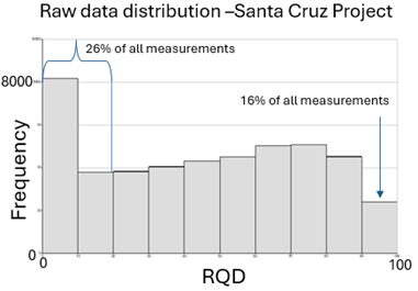
    The problem is rooted in data behaviour. Grade data typically exhibits smoother spatial patterns and lends itself to statistical interpolation. Geotechnical data doesn’t. Parameters like rock quality designation (RDQ), Q-values and fracture frequency often change abruptly because of faults, joints, lithological contacts and other structural features.

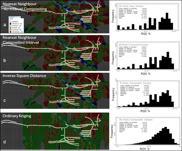
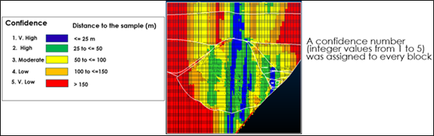
    When geostatistical methods are applied blindly to the geotechnical data, the model may look statistically sound, but can distort key structural features. This misrepresentation can lead to flawed support design, safety risks and costly planning errors. As one example illustrates, a model that is geostatistically “perfect” may completely miss a major fault zone, rendering it geotechnically useless. As shown in the image below, simply reusing the same methodology can grossly distort geotechnical data and erase important geological and geotechnical truths. The model at the bottom is geostatistically correct but geotechnically obsolete because it lost all trace of a major structure in between.

  2. Real-world example: Ivanhoe Electric’s Santa Cruz project

    At Ivanhoe Electric’s Santa Cruz project, two challenges exemplify why conventional methods were insufficient:

    1. Inverted data distribution: Unlike many hard rock projects where high rock quality is prevalent, Santa Cruz’s dataset included significant coverage in more variable zones, some with lower RQD and Q-values.

  3. 2. Geotechnical-mineralization correlation: There was a strong spatial link between mineralization zones and geotechnical conditions. Any model that ignored this relationship risked underestimating ground control needs in economically valuable areas.

  4. In both cases, traditional modelling techniques smoothed over the very features that mattered most.

    A better approach: Fitting the model to the geology

    After multiple iterations and reality checks, the project team adopted a geologically constrained modelling approach. Rather than compositing data and applying generalized geostatistics, they used nearest-neighbour interpolation on non-composited sample intervals. This method preserves localized variability and respects structural boundaries. This was key to building a model that best reflected actual ground conditions. The resulting geotechnical block model moves away from ‘theoretical concepts’ and focuses on being practically correct. It was directly deployable in the mine planning process and enabled:

    • More accurate estimation of ground support requirements (see image)
    • Reliable forecasting of development rates
    • Greater confidence in production scheduling

    To further support decision-making, the team also generated a confidence map alongside the block models. This map quantified the certainty of interpolated values and guided future drilling plans by identifying low-confidence zones in need of more data, as illustrated below.

  5. Final thought: Accuracy requires context

    In mine planning, accuracy isn’t just about mathematical precision; it’s about geological truth. A model that ignores the nature of its input data can mislead even the most experienced engineers.

    As geotechnical data continues to grow in both volume and importance, mining professionals must rethink their modelling strategies. That means selecting techniques that align with data behaviour and preserve geological integrity.

    Geotechnical block modelling isn’t just an extension of grade modelling. It’s a distinct discipline that requires its own tools, assumptions and validation methods. Focused research is needed to develop and improve geotechnical block modelling and model data utilization procedures.

This content is for general information purposes only. All rights reserved ©BBA

Publicaciones más recientes
Ver todo